
Eagan Historical Trail Guide
Introduction
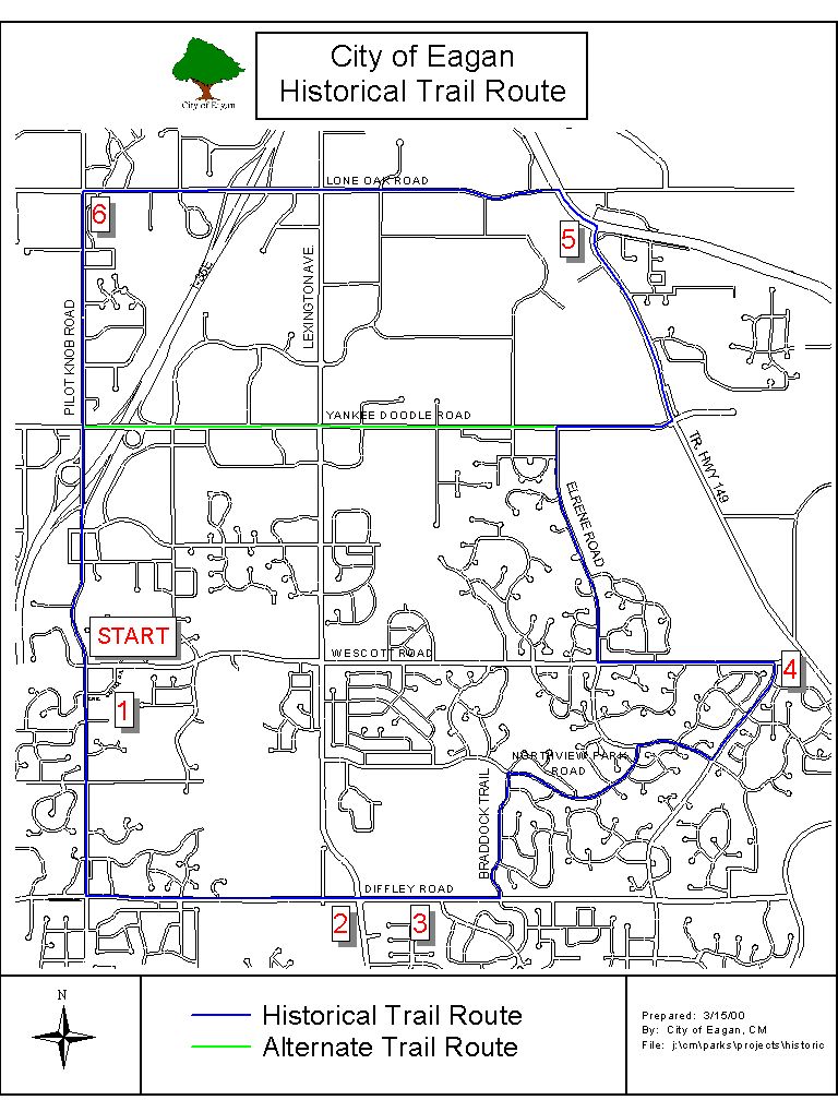
Welcome to the Eagan Historical Trail. The Eagan Historical Trail is an 12.2 mile urban trail designed to educate and inform adults and youths about significant events that helped shape the City of Eagan over the past 100 + years. The trail was designed by Eagle Scout candidate Matthew Brown of Troop 453 in conjunction with the City of Eagan, The Eagan Parks and Recreation Department and the Eagan Historical Society. We hope you enjoy your time on the trail and learning about Eagan’s history.
Use of the Trail Guide
This trail guide was developed to guide you along the path and to point out interesting and significant events that occurred in the City of Eagan. The trail starts and ends at the old city hall located at the intersection of Wescott and Pilot Knob Roads. This guide includes both a map of the trail and at the six major stops, a description of the points of interest and/or events that occurred in the vicinity. To gain a full appreciation of the historical events, it is suggested that trail leaders stop at the seven major stops and read the description of events to the group. The written descriptions will also provide a description of points of interest and/or events that occurred at intermediate points between the six major trail stops.
Please note that there is one short section of the trail (along Highway 13 and part of Lone Oak Road) where walkways are not present. Please exercise caution through this area and follow all safe hiking rules.
Alternate Short Route
If you are leading a group of younger hikers, particularly those under 12 years old, you may elect to bypass the section of the trail that follows Highway 13 to Lone Oak Road and follow Yankee Doodle Road back to Pilot Knob Road (see map for details) for a total trail distance of 9.6 miles. The alternative route diverts between trail stops 4 &5 and will not require hikers to hike along roadways. However, it is important that you stop and read through the description of events that occurred at stops #5 and #6 to fully appreciate the Eagan Historical Trail. Hikers completing the alternative route are still eligible to wear the Eagan Historical Trail emblem. However, to satisfy Boy Scout hiking merit badge requirement #4 the full 12.3-mile trail must be completed.
Trail Emblems
Upon completion of the trail, all scouts and leaders are eligible to receive and wear the Eagan Historical Trail emblem. Emblems are available at a cost of $1.00 at the Eagan City Hall. To receive emblems, leaders need to complete and submit the trail summary log. Emblems are available for completion of either the full route or the abbreviated route.
Parking
Parking is available in the Municipal Center parking lot while completing the trail. It is requested that the minimum number of vehicles to transport groups to and from the trailhead be utilized and parked in the lot.
Private Property
Since the Eagan Historical Trail winds through many residential neighborhoods, we ask that you follow the following rules:
Be mindful of private property. Please stay on the designated pathways and do not enter any private property except in an emergency.
Do not litter or leave trash along the trail. Waste receptacles are available in the public parks along the way.
Out of respect for the residents, please refrain from loud or raucous behavior while on the hike.
Safe Hiking Rules (Source: The Boy Scout Handbook eleventh edition)
Hiking along a highway or road
Stay in single file line on the left side facing the traffic
Obey all traffic signs and signals
Wear light colored clothing – allows drivers to see you easier
Avoid hiking along roadways at night – if unavoidable, wear strips of white cloth or reflective ribbon around your right arm and leg or wear a reflective vest like those worn by highway workers
Hike at a pace that is comfortable for the slowest member of the group
Take adequate rest breaks to allow hikers to adjust clothing, to check feet for hot spots and blisters and to allow for food and water.
Your safety is always much more important than reaching the destination of a hike
Trail Stop: #1 Trail Head
Location: Old City Hall – Pilot Knob and Wescott Road Intersection
Mileage: 0.0
Historic City Hall
In the first years of Eagan Township, the annual town meetings were usually conducted in the District 14 schoolhouse located near the intersection of Diffley and Lexington Roads. Often times, the Town Board of Supervisors met at the school or even in member’s homes. In 1892 a decision was reached that the first town hall be built on the land owned by Michael Shields which is presently at the intersection of Lone Oak and Pilot Knob Roads. But by 1914, a five-member committee was appointed to select a new site for the city hall and $500 was put aside to pay for the land and building.
The town board was not pleased with the recommendation of the committee and during this time, the original town hall was destroyed by fire. A special meeting was held on May 2, 1914 and the Town Board decided to locate the new hall as close to the exact center of the township as possible. A one-third acre of land next to Pilot Knob Road was purchased from Michael Englert and the 26X40-foot frame structure in front of you was constructed at a cost of $1,047. The building was completed on June 16, 1914 and served as the meeting hall and polling place for many decades.

Patrick Eagan Farm Site
The township of Eagan was named after Patrick Eagan who was the first chairman of the town board of supervisors. Patrick Eagan settled on a 220-acre parcel of land near the intersection of Pilot Knob and Wescott Roads. Patrick Eagan and his wife Margaret Twohy, were both born in Tipperary, Ireland in 1811 and 1816 respectively. They were married in Troy, New York in 1843. The records indicate that Patrick Eagan and his family arrived in the Mendota area around 1853-1854. Patrick served on the Mendota board for two years before the establishment of Eagan. He was elected six times as Eagan’s chairman.
Pilot Knob Road
The name Pilot Knob is attributed to the elevation of land near the intersection of Highways 13 and 55 (currently occupied by Acacia Cemetery). Pilot Knob was a reference point for riverboat pilots as they headed upstream to the landings at Mendota and Fort Snelling. Later on, Pilot Knob also became a geographical reference point for airplane pilots as they made their approach to the airport across the river in the 1920’s. Pilot Knob was also the site of the signing of the Treaty of 1851 with the lower Sioux tribes. Stephan A. Douglas (ran against Abraham Lincoln for president) who was the chairman of the congressional committee on organizing new territories, visited Pilot Knob as was impressed with the view. In 1849, Pilot Knob was listed as the location for the capitol when the bill for Minnesota’s territorial status was introduced. Later on, Henry Sibley convinced Congress to make St. Paul the capital instead of Mendota.
Location: Diffley and Lexington Roads – Lexington – Diffley Athletic Facility (southwest corner)
Mileage: 2.2 miles
Lexington-Diffley Airport Site
The area, which is now occupied by the Lexington-Diffley Athletic field, was used as a training airport during World War II. When the athletic field was constructed in the late 1990’s, a suggestion was made to name the field Touchdown Park in recognition of its prior use as an airport. The idea was rejected because of the connotation to football and not being representative of all of the sports (primarily baseball and softball) facilities. When the field was used as an airport, Dakota Electric was forced to bury a high-voltage line about one mile east of Lexington because of the hazard to low flying airplanes. This was Dakota Electric’s first underground high-voltage line.
On a side note, Eagan was also the site of two plane crashes in the summer of 1921. Neither of these crashes occurred at the Lexington-Diffley airport site. An airmail plane piloted by Mickey Eversole crashed on the Walter Sell farm near Lemay Lake, near the present bulk mail facility. The twin engine DeHaviland aircraft plummeted to the ground, but Mickey Eversole was able to parachute to safety. A week later a twin seat training plane crashed in the northwest corner of Eagan.


John McCarthy Homestead
Northwest of where you are standing, in what is now Patrick Eagan Park, stood the homestead of John McCarthy. John and his brother James left Chicago in the early 1850’s to settle in Eagan and split the original land claim into two 80-acre parcels. John’s first log cabin was destroyed by fire and was replaced by a second cabin in 1860. The walls of the second cabin still stand within a house in Eagan Park. John and his wife Bridgit had five children. Their son Flory graded roads in Eagan and helped to build Wescott Road.
Eagan’s First Church Services
Father Augustin Ravoux held the first church services in Eagan at the home of Edward Dowling sometime in 1854. The site of the Dowling home was in the vicinity of the intersection of Lexington and Diffley Roads.
Location: Diffley Road - Northview Elementary School
Mileage: 2.4 miles
District 14 Schoolhouse
According to county records, the first school in Eagan was taught by Michael Downing during the winter of 1859-60. Classes were conducted in a 14 X 16 foot log house (near the intersection of Lexington and Diffley) owned and built by Thomas Farman. The new school district was unusually large with about forty students, and after two years at the original location, a new log schoolhouse was constructed on the current site of Northview School. This log building lasted until 1875 when it was replaced by a frame structure and later by a brick building in 1898. From 1860 to 1892, the schoolhouse served as the location for the Annual Town Meetings.

Patrick Quigley Farm
The point where you are standing at one time was the location of the Patrick Quigley farm. Patrick Quigley was an Irish immigrant who settled in Eagan with his wife Margaret O’Gorman Quigley around 1850.
In August 1876, eight travelers got off the train in St. Paul posing as land speculators and cattle traders. After a short while in St. Paul they purchased the best horses and tack. Four of them headed west from Mendota to Mankato; the others headed south through Eagan, avoiding the Old Dodge Trail and riding cross-country. The four travelers rode up to the gate of the Quigley farm and were greeted by Patrick Quigley. The travelers were allowed to water and rest their horses and asked if they could travel across his property. Patrick Quigley was impressed by their fine clothing and polite manners and obliged their request as long as they closed all of the gates as they passed through. The passage of these four travelers was the height of conversation at the Quigley dinner table that evening, since it was unusual to take a cross-country route through Eagan. It wasn’t until some time after September 7, 1876 that Patrick Quigley concluded that he had obliged members of the infamous Jesse James gang on their way to rob the Northfield National Bank.
Location: Dodd and Wescott Roads
Mileage: 4.9 miles
¨ Eagan Historical Trail – alternate version diverts between trail stops #4 and #5 (see map).
Wescott Station
In the 1850’s, James Wescott opened an inn in eastern Eagan which fast became a favorite wagon and stage coach stop. As described in the 1881 history of Dakota County, Wescott’s Inn became famous throughout the county as a travelers rest also hosting local political conventions. With the expansion of railroads through southern Minnesota the Chicago, Milwaukee & St. Paul railroad (Minnesota Central) established a flag stop on the property of James Wescott in 1866. This area developed into a commercial center following the construction of a train depot. The Wescott Station area boasted a general store, grist mill, school, and a telegraph office. The store operated by Milo Stephens at Wescott in the 1920’s was the site of one of the first telephones in Eagan as well as an electric buzz saw.
Radio Center Site
In 1928 at the recommendation of a university professor, the Wescott area was selected to be the site of the National Battery Company’s radio center. The site was selected because it was considered to be high and dry. But by 1930 the opposite turned out to be true, and the center was moved. The center in Eagan first used the call letters KSTP which later became the company name.
Dodd Road
In the early 1850’s the lack of roads in southern Minnesota made it difficult for the settlers to reach the area much less being able to get farm products to the markets in St. Paul. Most of the roads at this time were labeled as "military roads" even though the settlers mostly used them. One of the earliest constructed roads was the Mendota-Big Sioux Road, or more commonly known as Dodd Road. This road was named for Captain William B. Dodd, who is credited with starting its construction.
Captain Dodd felt a need to construct a road between St. Paul and St. Peter (then known as Rock Bend) and was unable to receive government aid for the construction. Determined to build the road, Captain Dodd gathered funds from settlers and organized a work party of ten laborers and a surveyor. In the spring of 1853 the road between St. Peter and St. Paul was constructed. When finished the road, which was a path cut through the woods and prairie, stretched 65 miles and took 109 days to build.
In 1920, Minnesota created a system of state trunk highways and included the section of Dodd Road through Eagan as part of State Trunk Highway #1. The section of Dodd Road that lies between St. Paul and Eagan was among the first of the roads to be paved in Minnesota.
Location: Intersection of Highways 49 and 55
Mileage: 8.1
Yankee Doodle Road
Between trail stops # 4 and #5 you crossed Yankee Doodle Road one of the main east – west roads in the City of Eagan. However, Yankee Doodle Road wasn’t always known by its present name; rather prior to the World War I years, this road was known as Schmidt’s Road. At this point in Eagan’s history, it was common to name a road after the family whose farm the road ran past. Anti-German feelings due to the war were very high, and if a person lived on a road as German-sounding as "Schmidt’s Road" they would be subject to teasing. As the story goes, one of the residents of Schmidt’s Road who happened to be of German descent, was once publicly asked where he lived. To display his loyalty and to avoid the inevitable teasing, he said he lived on "Yankee Doodle Road," and the name has stayed the same ever since.
The Halfway House
In 1865, Alexander Huard opened a dry good store and saloon at what was once the crossing of Mendota and St. Paul Roads, now Highways 55 & 49. This location marked the halfway point between St. Paul and Hastings and was the first relay stop for stagecoaches traveling between St. Paul and Dubuque. The store was appropriately named the "Halfway House" and was a popular spot for soldiers stationed at Fort Snelling.
The Halfway House was best known for its tavern business even though business tapered off during the Prohibition years (1919-1933). Alexander Huard eventually sold the saloon to Peter Langan in 1885 and in 1913 it was taken over by Langan’s son Richard. The saloon was actually owned by the Joseph Schmidt Brewery Company from 1924 to 1959. The Halfway House was rented to George and May Hinze in 1930 and the name was changes to the Dixie Inn. Reportedly, the infamous gangster John Dillinger and members of the Ma Barker gang stopped in the saloon on trips to the Twin Cities. The saloon and restaurant continue to operate today.

Trinity Lone Oak Lutheran Church
Just north of where you are standing, you can see Trinity Lone Oak Lutheran Church on the east side of Dodd Road. This church was first organized in February 1881 and its first resident pastor was Reverend C. Robert Kaiser. One of the church’s charter members, August Nachtigall donated one acre of a two-acre site to build the original church (now the cemetery site). A 26 X 16 feet frame church building was constructed at a cost of $1,470 and was dedicated in January 1882. Unfortunately, the building was struck by lightning in 1901 and the bucket brigade was unable to save it from total destruction. Additional land was purchased and the existing church was built in 1902.
The church has operated a school since 1883 at which time all members were required to pay 75 cents a month for school maintenance. The school’s original teacher, Mr. Pommerening received $10.00 a month plus board.
Lone Oak Tree
Before there were any townships or roads in the area, a bur oak tree stood on the property of Trinity Lone Oak Church and was estimated to be around 200-300 years old. The tree stood on the church property for 115 years. Eagan’s "Lone Oak" was used to post official town notices and later on, advertisements for Eagan’s residents. When dairy farms operated in Eagan, farmers could leave milk cans in the shade of the tree to keep them cool until the milk haulers picked them up.
In 1974, the Highway Department not realizing the historical significance of the tree decided to cut the tree down. Reverend Richard Krenzke along with children of Trinity Lone Oak Church mustered community support to prevent the tree from being destroyed. In 1976 the Lone Oak Tree was given the designation of a Heritage Tree by the Minnesota State Horticultural Department and it has been listed in the book "Famous and Historic Trees" published by the American Forestry Association. Unfortunately by 1983, time, traffic and pollution starting to cause the tree to die and it was decided that the tree had to be cut down. A cross section of the tree currently hangs in the Eagan City Hall outside of the council chambers. The symbol of the Lone Oak Tree serves as an icon for the City of Eagan – "The Symbol of Strength and Growth in our Community".

Location: Intersection of Lone Oak Road and Pilot Knob Road
Mileage: 10.2 miles
Shields Sorghum Mill
The intersection of Lone Oak and Pilot Knob Roads was once the site of a home owned by Michael Shields. Michael was the son of John Shields, an Irish immigrant who came to the United States in the mid-1840’s. Michael Shields operated one of the earliest businesses in Eagan, Shield’s Sorghum Mill. This mill operated from 1899 to 1911 and produced sorghum, a syrup made from amber sugar cane. At the beginning, the cane was milled on the Shield’s farm but by the early 1890’s a new and separate mill was built (east of the intersection of Lone Oak and Pilot Knob Roads). The mill was two stories high with a stone-walled basement. Inside the mill was a press run by a 12 horsepower steam engine. There were also two 200 gallon boilers that used water drawn from LeMay Lake.
The mill opened in the fall when sorghum cane was harvested. This signified the official start for the season and became a social event. Dignitaries such as Archbishop Ireland and James J. Hill would frequently attend this event. The mill ran 24-hours a day, 7 days a week from September through October. A typical work crew consisted of 10-12 men working 12 hour shifts.
Shields-by-the-Lake
During the 1920’s through the 1940’s, a barn on the Shield’s property was converted into a dance hall. It has been said that many of Eagan’s residents met their spouses at dances held at this popular spot. The building still exists today.
District 11 Schoolhouse
Near the intersection of Lone Oak and Pilot Knob Roads stood the schoolhouse for District 11. The schoolhouse was an 18 X 26 foot structure with a seating capacity of 40 students built at a cost of $600. One of the students who attended school in this building was Herbert Polzin. Herbert’s grandfather immigrated to the United States in 1872 and settled in the West St. Paul area. He later married Minna Volk and together they had three children including Gusatve, Herbert’s father. Herbert Polzin served Eagan in a variety of capacities, including an election judge when he was 21, moderator of many town meetings and from 1944 to 1972 the town treasurer. Later in 1972, Herbert Polzin was elected as the first mayor of the Village of Eagan and then from 1974 to 1978 he served two terms as mayor for the newly created City of Eagan. Herbert Polzin passed away in 1981 and was interred in Acacia Cemetery (Pilot Knob).
Trail End
Location: Old City Hall - Intersection of Pilot Knob and Wescott Roads
Mileage: 12.2 miles
Additional Historic Sites in Eagan
While the Eagan Historical Trail passes by many of the areas that influenced the city’s history, it should be noted that there are other areas of the city that have historical significance. Here are some other historical sites and their respective location in the city. To learn more about these sites, please refer to the sources cited at the end of this guide.
Black Dog’s Village Site: Near Highway 13 and Blackhawk Road
Black Dog Group Native American burial mounds: Cedar Avenue and Highway 13
Nichols Station site: Nichols Road and Union Pacific tracks
St. Johns Lutheran Cemetery: Diffley and Blackhawk Roads
Old Cedar Avenue Bridge: Cedar Avenue and Minnesota River
Moonshine Park: South shore of Lemay Lake
Sources:
City of Eagan, Minnesota. Lone Oak Years A History of Eagan, Minnesota.
West Group, Eagan, Minnesota, 1985.
Eagan Historical Society and Dakota County Historical Society. The City of Eagan. Highlights of our History and Heritage Map. Eagan, Minnesota. 1998
Special Thanks:
Special thanks go to the following individuals and groups for their assistance in helping create the Eagan Historical Trail.
Mr. Paul Olson
Mr. Tom Hedges
Ms. Joanna Foote
Mr. Ted Wachter
The Eagan Historical Society
Eagan Parks & Recreation Department
Leaders and Scouts of Troop 453